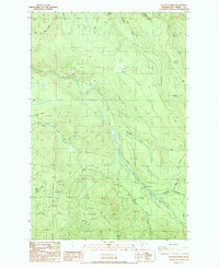
1987 Map of Le Dout Creek
USGS Topo · Published 1987About this map
The Puyallup River and its glacial-fed tributaries dominate this landscape on the western approaches to the Cascades in the late twentieth century. This terrain is defined by a series of steep drainages, including Le Dout Creek and Voight Creek, which flow north from the high ground known as The Divide. Along the river valley, evidence of mountain-dependent infrastructure is visible, including a Flume, a small Dam, and a Gaging Station located near the confluence with the Mowich River.
Find a feature on this map
24 named features on this map. Tap any name to fly to it.
Don’t see what you’re looking for? This feature index may not catch every label — zoom into the map to look around manually.
Map Details
Editions of this 1987 Le Dout Creek Map
2 editions found
Other maps of this area

1897 · Tacoma
USGS Topo · 1:125,000

1900 · Tacoma
USGS Topo · 1:125,000

1913 · Cedar Lake
USGS Topo · 1:125,000

1924 · Mt Rainier
USGS Topo · 1:96,000

1928 · Mt Rainier
USGS Topo · 1:125,000

1937 · Eatonville
USGS Topo · 1:125,000

1942 · Lake Tapps
USGS Topo · 1:62,500

1944 · Lake Tapps
USGS Topo · 1:62,500

1950 · Yakima
USGS Topo · 1:250,000

1953 · Hoquiam
USGS Topo · 1:250,000