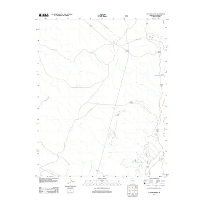
2012 Map of Le Fevre Ridge
USGS Topo · Published 2012About this map
Le Fevre Ridge defines the high ground of this high-country landscape in Coconino County, where the topography is shaped by a network of drainage patterns and forest management corridors. The presence of the South Cutler Pockets Corral and the Wittis Gravel Pit reflects a land utilized for both traditional grazing and local resource extraction. Transportation across the ridge is anchored by Alt 89, which serves as the primary artery through this area, supported by a system of secondary routes like Ryan Rd and various forest service roads. Public access and tourism are highlighted by the LeFevre Overlook and LeFevre Rest Area, providing vantage points over the varied terrain. Smaller water features like Hidden Lake and localized depressions like Cutler Pockets offer unique points of interest within the broader ridge environment.
Find a feature on this map
18 named features on this map. Tap any name to fly to it.
Don’t see what you’re looking for? This feature index may not catch every label — zoom into the map to look around manually.
Map Details
Editions of this 2012 Le Fevre Ridge Map
This is the sole edition of this map. No revisions or reprints were ever made.
Other maps of this area

1886 · Kaibab
USGS Topo · 1:250,000

1936 · Jacobs Lake
USGS Topo · 1:48,000

1940 · Jacob Lake
USGS Topo · 1:62,500

1953 · Jacobs Lake
USGS Topo · 1:62,500

1953 · Grand Canyon
USGS Topo · 1:250,000

1954 · Shinarump NW
USGS Topo · 1:24,000

1957 · Grand Canyon
USGS Topo · 1:250,000
1957 · Shinarump NE
USGS Topo · 1:24,000
1957 · House Rock Spring NW
USGS Topo · 1:24,000

1957 · Shinarump SE
USGS Topo · 1:24,000