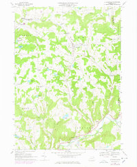
1967 Map of Le Raysville
USGS Topo · Published 1978About this map
Le Raysville sits at the heart of this Susquehanna Valley landscape, where the agricultural uplands of Orwell and Pike townships meet the winding waters of Wyalusing Creek. This mid-century survey captures a rural Pennsylvania community defined by its crossroads and water bodies, from the cluster of buildings at Stevensville to the isolated St Matthews Ch and the Centerville Cem. The map reveals a network of dairy farms and small settlements like Brushville, East Herrick, and Chaffee Corners, many of which developed around early schools like the Maple Grove Sch. Natural features like Totem Lake, Leisure Lakes, and Ross Hill dominate the topography, while a lone Quarry and the Giffin Landing Strip hint at the local industries and transport methods of the late 1960s. The 1978 photorevisions, indicated in purple, trace subtle changes in the road network and field lines as the region evolved.
Find a feature on this map
50 named features on this map. Tap any name to fly to it.
Don’t see what you’re looking for? This feature index may not catch every label — zoom into the map to look around manually.
Map Details
Editions of this 1967 Le Raysville Map
2 editions found
Other maps of this area

1923 · Towanda
USGS Topo · 1:62,500

1926 · Towanda
USGS Topo · 1:62,500

1943 · Towanda
USGS Topo · 1:62,500

1943 · Monroeton
USGS Topo · 1:62,500

1943 · Le Raysville
USGS Topo · 1:62,500

1945 · Le Raysville
USGS Topo · 1:62,500

1945 · Meshoppen
USGS Topo · 1:62,500

1945 · Auburn Center
USGS Topo · 1:24,000

1945 · Laceyville
USGS Topo · 1:24,000
1947 · Auburn Center
USGS Topo · 1:31,680