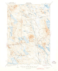
1932 Map of Lead Mountain
USGS Topo · Published 1945About this map
The Narraguagus River system anchors this survey of Hancock and Washington Counties, illustrating a wilderness landscape shaped by timber camps and early 20th-century recreation. Significant peaks like Lead Mtn and Eagle Mtn rise above a dense network of waters including Alligator Lake, Eagle Lake, and Beddington Lake. Atop Lead Mountain, a Fire Tower overlooks the surrounding townships, while Hemlock Dam indicates the industrial management of local waterways.
Find a feature on this map
109 named features on this map. Tap any name to fly to it.
Don’t see what you’re looking for? This feature index may not catch every label — zoom into the map to look around manually.
Map Details
Editions of this 1932 Lead Mountain Map
5 editions found
Other maps of this area

1902 · Cherryfield
USGS Topo · 1:62,500

1904 · Cherryfield
USGS Topo · 1:62,500

1911 · Ellsworth
USGS Topo · 1:62,500

1929 · Great Pond
USGS Topo · 1:48,000

1929 · Lead Mountain
USGS Topo · 1:48,000

1930 · Tunk Lake
USGS Topo · 1:48,000

1931 · Saponac
USGS Topo · 1:48,000

1932 · Tunk Lake
USGS Topo · 1:62,500

1932 · Nicatous Lake
USGS Topo · 1:48,000

1932 · Lead Mountain
USGS Topo · 1:62,500