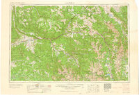
1960 Map of Leadville
USGS Topo · Published 1960About this map
The high-altitude industrial and mountain landscapes of central Colorado are documented here in the late 1950s, anchored by the mining hub of Leadville and the growing resort of Aspen. This survey captures the region during a period of transition, showing the massive Climax Molybdenum Mine at Fremont Pass and the Camp Hale (Military Reservation) site north of the Continental Divide. The rail network is dominated by the Denver and Rio Grande Western RR, which follows the courses of the Colorado River and Eagle River through towns like Minturn and Glenwood Springs. Physical geography is marked by the towering peaks of the Sawatch Mountains, including Mount Elbert, and the distinct geological formations of the Grand Hogback in the west. These valley settlements, once driven by silver and coal, appear here as they began to pivot toward modern recreation and infrastructure.
Find a feature on this map
82 named features on this map. Tap any name to fly to it.
Don’t see what you’re looking for? This feature index may not catch every label — zoom into the map to look around manually.
Map Details
Editions of this 1960 Leadville Map
2 editions found

Other maps of this area

1888 · Crested Butte
USGS Topo · 1:62,500

1888 · Anthracite
USGS Topo · 1:62,500

1889 · Crested Butte
USGS Topo · 1:62,500

1889 · Anthracite
USGS Topo · 1:62,500

1889 · Leadville
USGS Topo · 1:125,000

1891 · Leadville
USGS Topo · 1:125,000

1893 · Anthracite
USGS Topo · 1:62,500

1893 · Crested Butte
USGS Topo · 1:62,500

1893 · Aspen
USGS Topo · 1:62,500

1894 · Anthracite
USGS Topo · 1:62,500