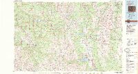
1983 Map of Leadville
USGS Topo · Published 1983About this map
Mount Elbert and Mount Massive dominate the central skyline of this high-altitude landscape, which anchors the intersection of the Sawatch Range and the Mosquito Range. In the early 1980s, the region was defined by a complex balance of industrial activity and protected wilderness. Major operations like the Climax Mine and Henderson Mine sit in close proximity to the vast White River National Forest and Holy Cross Wilderness. The map traces the industrial corridor along the Arkansas River, where the Denver and Rio Grande Western RR served mining and transit needs near Leadville. On the western slopes, the development of Snowmass Village and Aspen along the Roaring Fork River highlights the era's shift toward recreation, while the Leadville Federal Fish Hatchery remains a notable landmark of federal presence in the valley.
Find a feature on this map
121 named features on this map. Tap any name to fly to it.
Don’t see what you’re looking for? This feature index may not catch every label — zoom into the map to look around manually.
Map Details
Editions of this 1983 Leadville Map
2 editions found
Other maps of this area

1888 · Crested Butte
USGS Topo · 1:62,500

1888 · Anthracite
USGS Topo · 1:62,500

1889 · Crested Butte
USGS Topo · 1:62,500

1889 · Anthracite
USGS Topo · 1:62,500

1889 · Leadville
USGS Topo · 1:125,000

1891 · Leadville
USGS Topo · 1:125,000

1893 · Anthracite
USGS Topo · 1:62,500

1893 · Crested Butte
USGS Topo · 1:62,500

1893 · Aspen
USGS Topo · 1:62,500

1894 · Anthracite
USGS Topo · 1:62,500