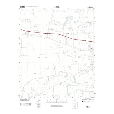
2010 Map of Leary
USGS Topo · Published 2010About this map
Red Springs and Red Lick anchor this Bowie County landscape west of Texarkana, where local commerce and community life follow the path of the Interstate 30 corridor. The map reveals a dense network of country roads and family-centered landmarks, particularly evident in the high concentration of burial grounds such as Carpenter Cemetery, Bob Lane Cemetery, and Price Cemetery. These sites, along with the Red Springs Cemetery and Piney Grove Cemetery, provide a clear spatial record for genealogists tracing local family roots. The terrain is defined by a series of south-flowing waterways, including Akin Creek and Boone Creek, which drain toward the Red River basin. A prominent landmark, the Redwater Lookout Tower, stands near the southern edge of the survey, overlooking the transition from the small settlements of Victory City and Leary to the more developed areas near Nash.
Find a feature on this map
67 named features on this map. Tap any name to fly to it.
Don’t see what you’re looking for? This feature index may not catch every label — zoom into the map to look around manually.
Map Details
Editions of this 2010 Leary Map
This is the sole edition of this map. No revisions or reprints were ever made.
Other maps of this area

1909 · New Boston
USGS Topo · 1:62,500

1909 · Texarkana
USGS Topo · 1:62,500

1950 · Redbank
USGS Topo · 1:24,000

1950 · Ogden
USGS Topo · 1:24,000

1950 · Barkman
USGS Topo · 1:24,000

1951 · Redbank
USGS Topo · 1:24,000

1951 · Ogden
USGS Topo · 1:24,000

1951 · Barkman
USGS Topo · 1:24,000

1953 · Texarkana
USGS Topo · 1:250,000

1954 · Texarkana
USGS Topo · 1:24,000