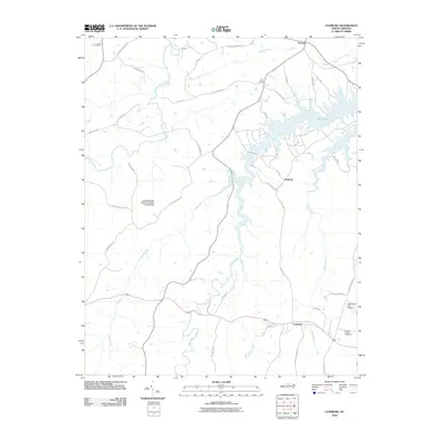
2010 Map of Leasburg
USGS Topo · Published 2010About this map
Leasburg and the rural stretches of Caswell County are defined by a complex network of waterways feeding into the sprawling Hyco Lake. The landscape transition from traditional agriculture to modern land management is evident in the presence of the Caswell Wildlife Mgmt Pond Dam Number Two, reflecting the region's importance for conservation and recreation. Small, historically significant settlements such as Semora, Yarbro, and Osmond anchor the local road network, which is often named after established local families and landmarks like Yarboroughs Mill Rd and Longs Mill Rd. Genealogists will find particular value in the documentation of the Gilead Cemetery and Ebenezer Church Cemetery, alongside unique infrastructure like the Winstead '76' Airport. The map traces the intricate paths of Country Line Creek and Hyco Creek, which historically dictated the settlement patterns and road placements throughout this North Carolina piedmont area.
Find a feature on this map
44 named features on this map. Tap any name to fly to it.
Don’t see what you’re looking for? This feature index may not catch every label — zoom into the map to look around manually.
Map Details
Editions of this 2010 Leasburg Map
This is the sole edition of this map. No revisions or reprints were ever made.
Other maps of this area

1923 · Danville
USGS Topo · 1:48,000

1925 · Danville
USGS Topo · 1:62,500

1952 · Milton
USGS Topo · 1:62,500

1953 · Greensboro
USGS Topo · 1:250,000

1954 · Greensboro
USGS Topo · 1:250,000

1956 · Milton
USGS Topo · 1:62,500

1962 · Greensboro
USGS Topo · 1:250,000

1965 · Ringgold
USGS Topo · 1:24,000

1966 · Greensboro
USGS Topo · 1:250,000

1968 · Leasburg
USGS Topo · 1:24,000