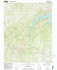
1997 Map of Leasburg
USGS Topo · Published 2000About this map
Hyco Lake dominates the upper reaches of the landscape, its branching fingers following the natural drainage of Kilgore Creek and Hyco Creek along the border of Caswell Co and Person Co. The map reveals a rural transition near the turn of the millennium, where old road networks like Longs Mill Road and Hesters Store Road connect long-standing community centers. Leasburg and Semora anchor the north and south, characterized by a high density of local churches such as Union Ch and New Hope Ch. The presence of the Blanch Prison and several game lands suggests a landscape largely dedicated to state-managed property and agriculture. Genealogists may find value in the specific locations of rural institutions, including the High Rock Sch and numerous unnamed family cemeteries scattered across the ridge lines.
Find a feature on this map
46 named features on this map. Tap any name to fly to it.
Don’t see what you’re looking for? This feature index may not catch every label — zoom into the map to look around manually.
Map Details
Editions of this 1997 Leasburg Map
This is the sole edition of this map. No revisions or reprints were ever made.
Other maps of this area

1923 · Danville
USGS Topo · 1:48,000

1925 · Danville
USGS Topo · 1:62,500

1952 · Milton
USGS Topo · 1:62,500

1953 · Greensboro
USGS Topo · 1:250,000

1954 · Greensboro
USGS Topo · 1:250,000

1956 · Milton
USGS Topo · 1:62,500

1962 · Greensboro
USGS Topo · 1:250,000

1965 · Ringgold
USGS Topo · 1:24,000

1966 · Greensboro
USGS Topo · 1:250,000

1968 · Leasburg
USGS Topo · 1:24,000