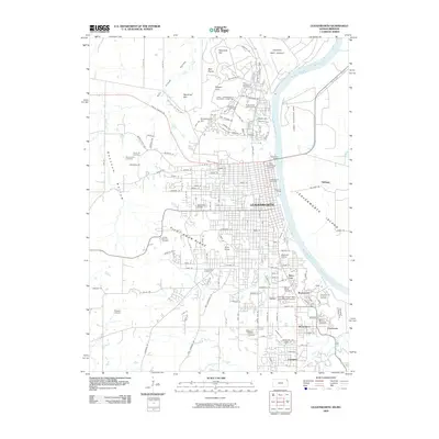
2009 Map of Leavenworth
USGS Topo · Published 2009About this map
The Missouri River defines the eastern edge of this landscape, where the long-established military and civic presence of Leavenworth and Lansing has shaped the terrain. This area is characterized by a high concentration of institutional landmarks, from the Fort Leavenworth National Cemetery and Sherman Army Airfield in the north to the Federal Penitentiary Farm along the riverbanks. The city’s historic grid is evident near The Leavenworth Landing, while the southern reaches include the University of Saint Mary Leavenworth Campus and the community of Wadsworth. Prominent landforms like Pilot Knob Ridge and Sentinel Hill rise above the drainage systems of Threemile Creek and Fivemile Creek. Numerous burial grounds, including Mount Muncie Cemetery and Greenwood Cemetery, reflect the deep genealogical roots of this river-port and military hub.
Find a feature on this map
101 named features on this map. Tap any name to fly to it.
Don’t see what you’re looking for? This feature index may not catch every label — zoom into the map to look around manually.
Map Details
Editions of this 2009 Leavenworth Map
This is the sole edition of this map. No revisions or reprints were ever made.
Other maps of this area

1886 · Oskaloosa
USGS Topo · 1:125,000

1888 · Oskaloosa
USGS Topo · 1:125,000

1890 · Kansas City
USGS Topo · 1:125,000

1894 · Kansas City
USGS Topo · 1:125,000

1894 · Oskaloosa
USGS Topo · 1:125,000

1910 · Leavenworth
USGS Topo · 1:62,500

1934 · Bonner Springs
USGS Topo · 1:48,000

1934 · Wolcott
USGS Topo · 1:24,000

1940 · Bonner Springs
USGS Topo · 1:62,500
1948 · Wolcott
USGS Topo · 1:24,000