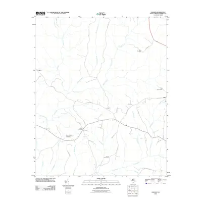
2011 Map of Lebanon
USGS Topo · Published 2011About this map
The settlement of Lebanon serves as a central hub in this rural Fairfield County landscape, where the geography is defined by a dense network of watercourses including the Little River and Brushy Fork Creek. For genealogical researchers, the map is particularly detailed regarding local burial sites, documenting the Old Stone Church Cemetery, Lebanon Cemetery, Turner Cemetery, and Saint Johns Cemetery. This 2011 survey captures the area's transition into the 21st century, showing modern road developments like Kincaid Bridge Rd and Old Airport Rd alongside traditional landmarks. To the northwest, the community of Douglass sits near the upper reaches of the Little River, while the White Oak Lookout Tower stands as a prominent point of interest in the northeast corner near the Fairfield-Chester border. The southern portion of the quadrangle is marked by Jackson Creek and several dammed water bodies, including the South Carolina Noname 20019 D-0520 Dam.
Find a feature on this map
41 named features on this map. Tap any name to fly to it.
Don’t see what you’re looking for? This feature index may not catch every label — zoom into the map to look around manually.
Map Details
Editions of this 2011 Lebanon Map
This is the sole edition of this map. No revisions or reprints were ever made.
Other maps of this area

1904 · Columbia
USGS Topo · 1:125,000

1941 · Spartanburg
USGS Topo · 1:250,000

1953 · Spartanburg
USGS Topo · 1:250,000

1960 · Spartanburg
USGS Topo · 1:250,000

1963 · Spartanburg
USGS Topo · 1:250,000

1964 · Spartanburg
USGS Topo · 1:250,000

1968 · Blackstock
USGS Topo · 1:24,000

1969 · Lebanon
USGS Topo · 1:24,000
1969 · Jenkinsville
USGS Topo · 1:24,000
1969 · Salem Crossroads
USGS Topo · 1:24,000