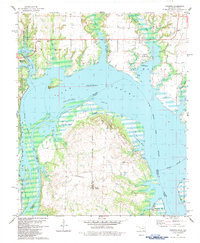
1982 Map of Lebanon
USGS Topo · Published 1983About this map
The Red River creates a meandering border between Oklahoma and Texas, defining the geography of the Delaware Bend region. On the Oklahoma side, the small settlements of Lebanon and Enville sit amidst a landscape of cattle pastures and wooded creeks, including Hickory Creek and Boggy Creek. This early 1980s data shows the local infrastructure of the era, from the Pleasant Oak Cem to the scattered gas and oil wells that dot the hillsides.
Find a feature on this map
43 named features on this map. Tap any name to fly to it.
Don’t see what you’re looking for? This feature index may not catch every label — zoom into the map to look around manually.
Map Details
Editions of this 1982 Lebanon Map
This is the sole edition of this map. No revisions or reprints were ever made.
Other maps of this area

1901 · Tishomingo
USGS Topo · 1:125,000

1901 · Ardmore
USGS Topo · 1:125,000

1901 · Denison
USGS Topo · 1:125,000

1902 · Gainesville
USGS Topo · 1:125,000

1918 · Ardmore
USGS Topo · 1:125,000

1943 · Gainesville
USGS Topo · 1:125,000

1954 · Sherman
USGS Topo · 1:250,000

1957 · Ardmore
USGS Topo · 1:250,000

1958 · Gordonville
USGS Topo · 1:62,500

1958 · Sherman
USGS Topo · 1:250,000