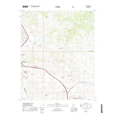
2018 Map of Lebec
USGS Topo · Published 2018About this map
Gorman sits at a critical junction of the Tejon Pass, where the San Andreas Fault cuts a distinct line through the topography. This 2018 survey illustrates the complex water infrastructure of the region, specifically the Governor Edmund G Brown West Branch California Aqueduct as it moves toward the Carley V Porter Tunnel and Quail Lake. The landscape is dominated by the steep rises of the Tehachapi Mountains and San Emigdio Mountains, framing the high-altitude Peace Valley. Large-scale land management is evident as the map transitions between the Los Padres National Forest and Angeles National Forest. Local landmarks like Castac Lake and the residential pockets of Castac Valley provide a grounded perspective on human settlement amidst the geological scale of the surrounding canyons and peaks.
Find a feature on this map
51 named features on this map. Tap any name to fly to it.
Don’t see what you’re looking for? This feature index may not catch every label — zoom into the map to look around manually.
Map Details
Editions of this 2018 Lebec Map
This is the sole edition of this map. No revisions or reprints were ever made.
Other maps of this area

1903 · Tejon
USGS Topo · 1:125,000

1933 · Quail
USGS Topo · 1:24,000

1933 · Gorman
USGS Topo · 1:24,000

1938 · Gorman
USGS Topo · 1:24,000

1938 · Quail
USGS Topo · 1:24,000

1942 · Tecuya Creek
USGS Topo · 1:24,000

1942 · Frazier Mountain
USGS Topo · 1:24,000

1943 · Neenach
USGS Topo · 1:62,500
1944 · Frazier Mountain
USGS Topo · 1:31,680
1945 · Pastoria Creek
USGS Topo · 1:31,680