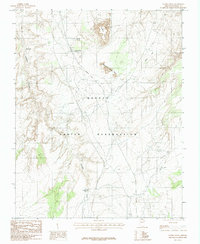
1985 Map of Leche-E Rock
USGS Topo · Published 1985About this map
The Navajo Indian Reservation landscape is defined by its striking high-desert topography, dominated by the prominent sandstone formation of Leche-e Rock. Surveyed in the late 1970s, this area of Coconino County reveals a pattern of scattered water sources essential for life in the arid environment. Water access points like Cottonwood Spring, Shanks Spring, and Antelope Tank are interspersed among named terrain features such as Mountain Sheep Rock and White Hill. The mapping of Antelope Creek and its surrounding drainage basins provides a clear view of how the natural geography dictated movement and land use within the reservation during this period. The inclusion of traditional place names like Bighahilini reflects the cultural continuity and indigenous geography of this portion of northern Arizona.
Find a feature on this map
10 named features on this map. Tap any name to fly to it.
Don’t see what you’re looking for? This feature index may not catch every label — zoom into the map to look around manually.
Map Details
Editions of this 1985 Leche-E Rock Map
This is the sole edition of this map. No revisions or reprints were ever made.
Other maps of this area

1886 · Echo Cliffs
USGS Topo · 1:250,000

1891 · Echo Cliffs
USGS Topo · 1:250,000

1954 · Leche-E Rock
USGS Topo · 1:62,500

1954 · Navajo Creek
USGS Topo · 1:62,500

1956 · Marble Canyon
USGS Topo · 1:250,000

1959 · Marble Canyon
USGS Topo · 1:250,000

1961 · Marble Canyon
USGS Topo · 1:250,000
1981 · Horsethief Mesa
USGS Topo · 1:24,000
1982 · Many Ghosts Hill
USGS Topo · 1:24,000
1982 · Dead Monkey Ridge
USGS Topo · 1:24,000