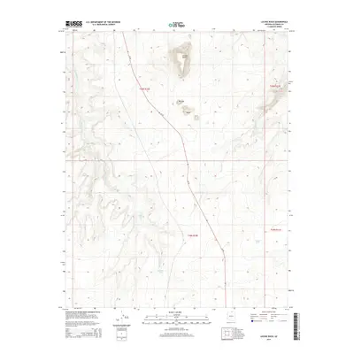
2014 Map of LeChee Rock
USGS Topo · Published 2014About this map
LeChee Rock serves as the central landmark of this Coconino County terrain, standing amidst a landscape defined by seasonal watercourses and arid plateaus. The drainage patterns of Antelope Creek and the long course of Sand Wash dominate the topography, illustrating the erosional forces at work in the high desert. Settlement and activity are concentrated near established routes like Az-98, which cuts diagonally across the township lines. Cultural and topographical points of interest such as Nurusse and Betay provide specific geographic anchors for the region. Artificial water features, including Antelope Tank and Alkali Tank, underscore the necessity of water management in this environment. This 2014 survey captures the intersection of natural desert features and modern infrastructure in the vicinity of the Navajo Nation.
Find a feature on this map
13 named features on this map. Tap any name to fly to it.
Don’t see what you’re looking for? This feature index may not catch every label — zoom into the map to look around manually.
Map Details
Editions of this 2014 LeChee Rock Map
This is the sole edition of this map. No revisions or reprints were ever made.
Other maps of this area

1886 · Echo Cliffs
USGS Topo · 1:250,000

1891 · Echo Cliffs
USGS Topo · 1:250,000

1954 · Leche-E Rock
USGS Topo · 1:62,500

1954 · Navajo Creek
USGS Topo · 1:62,500

1956 · Marble Canyon
USGS Topo · 1:250,000

1959 · Marble Canyon
USGS Topo · 1:250,000

1961 · Marble Canyon
USGS Topo · 1:250,000
1981 · Horsethief Mesa
USGS Topo · 1:24,000
1982 · Many Ghosts Hill
USGS Topo · 1:24,000
1982 · Dead Monkey Ridge
USGS Topo · 1:24,000