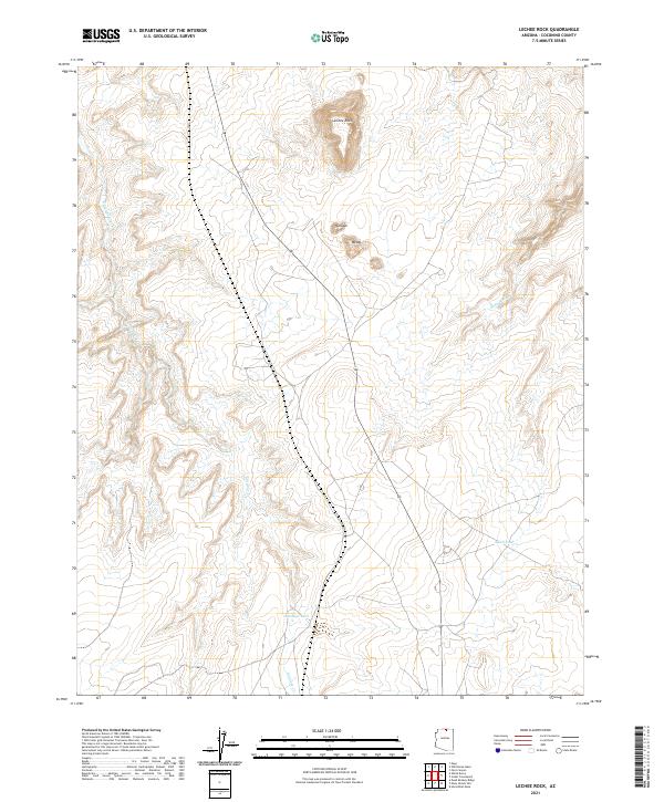
2021 Map of LeChee Rock
USGS Topo · Published 2021About this map
LeChee Rock stands as a prominent landmark in this high-desert landscape of Coconino County, characterized by its intricate drainage networks and isolated water sources. Small settlements such as Betay and Nurusse are positioned near established routes, providing a glimpse into the modern habitation of the area. The terrain is deeply incised by Antelope Creek and its various branches, including Antelope Creek, which flow toward the northwest. For those studying the hydrology of the region, the placement of isolated reservoirs like Antelope Tank and Alkali Tank indicates the critical importance of water management in an environment where seasonal flows, such as those in Sand Wash, define the movement of both people and livestock across the township and range grid.
Find a feature on this map
14 named features on this map. Tap any name to fly to it.
Don’t see what you’re looking for? This feature index may not catch every label — zoom into the map to look around manually.
Map Details
Editions of this 2021 LeChee Rock Map
This is the sole edition of this map. No revisions or reprints were ever made.
Other maps of this area

1886 · Echo Cliffs
USGS Topo · 1:250,000

1891 · Echo Cliffs
USGS Topo · 1:250,000

1954 · Leche-E Rock
USGS Topo · 1:62,500

1954 · Navajo Creek
USGS Topo · 1:62,500

1956 · Marble Canyon
USGS Topo · 1:250,000

1959 · Marble Canyon
USGS Topo · 1:250,000

1961 · Marble Canyon
USGS Topo · 1:250,000
1981 · Horsethief Mesa
USGS Topo · 1:24,000
1982 · Many Ghosts Hill
USGS Topo · 1:24,000
1982 · Dead Monkey Ridge
USGS Topo · 1:24,000