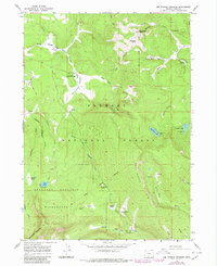
1966 Map of Lee Thomas Crossing
USGS Topo · Published 1980About this map
The Old Indian Treaty Boundary carves a diagonal line across this high-elevation landscape within the Fremont National Forest, marking a significant historical border amidst the timber and meadows. Centered on the upper reaches of the Meadow Sprague River and its North Fork, the map reveals a wilderness transition where the Gearhart Mountain Wilderness dominates the southwest. This area is characterized by high peaks and remote water sources, including the isolated Blue Lake and Gearhart Marsh near the base of Gearhart Mountain.
Find a feature on this map
53 named features on this map. Tap any name to fly to it.
Don’t see what you’re looking for? This feature index may not catch every label — zoom into the map to look around manually.
Map Details
Editions of this 1966 Lee Thomas Crossing Map
2 editions found
Other maps of this area

1955 · Klamath Falls
USGS Topo · 1:250,000

1958 · Klamath Falls
USGS Topo · 1:250,000

1960 · Fishhole Mtn
USGS Topo · 1:62,500

1964 · Coleman Point
USGS Topo · 1:24,000

1966 · Shake Butte
USGS Topo · 1:24,000

1966 · Slide Mtn
USGS Topo · 1:24,000

1966 · Sandhill Crossing
USGS Topo · 1:24,000

1966 · Harvey Creek
USGS Topo · 1:24,000

1966 · Coffeepot Creek
USGS Topo · 1:24,000

1966 · Lee Thomas Crossing
USGS Topo · 1:24,000