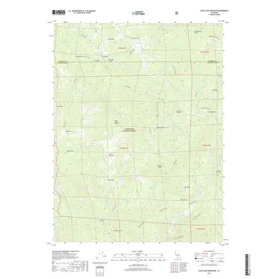
2018 Map of Leech Lake Mountain
USGS Topo · Published 2018About this map
Mendocino National Forest defines the character of this mountainous landscape where the Middle Fork Eel River carves through the northern California backcountry. High peaks and ridges dominate the topography, with landmarks such as Leech Lake Mtn and Castle Peak providing significant elevation changes. Historically, the area relied on rugged transit routes like the Pillsbury-Indian Dick road and the Travelers Home trail, reflecting the movement patterns of early forest rangers and backpackers. Numerous water features like Leech Lake, Dewell Lake, and Grass Lake dot the ridges, suggesting a complex hydrology that supports distinct alpine environments like Airplane Meadow. The map also captures several springs and glades, including Thistle Spring and Foster Glades, which have long served as vital points for those navigating these remote drainage systems.
Find a feature on this map
50 named features on this map. Tap any name to fly to it.
Don’t see what you’re looking for? This feature index may not catch every label — zoom into the map to look around manually.
Map Details
Editions of this 2018 Leech Lake Mountain Map
This is the sole edition of this map. No revisions or reprints were ever made.
Other maps of this area

1890 · Red Bluff
USGS Topo · 1:250,000

1894 · Red Bluff
USGS Topo · 1:250,000

1926 · Covelo
USGS Topo · 1:62,500

1931 · Hoaglin
USGS Topo · 1:96,000

1935 · Hoaglin
USGS Topo · 1:125,000

1952 · Covelo
USGS Topo · 1:62,500

1952 · Anthony Peak
USGS Topo · 1:62,500

1953 · Blackrock Mtn
USGS Topo · 1:62,500

1954 · Blackrock Mtn
USGS Topo · 1:62,500

1954 · Yolla Bolly
USGS Topo · 1:62,500