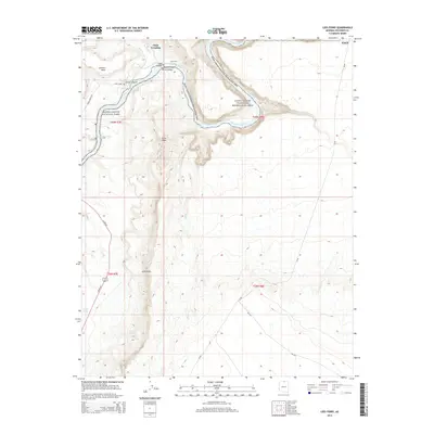
2014 Map of Lees Ferry
USGS Topo · Published 2014About this map
Lees Ferry serves as a critical historical point where the Paria River meets the Colorado River, marking the gateway between Glen Canyon National Recreation Area and Grand Canyon National Park. This landscape is defined by its deep canyons and towering rock formations, including the formidable Echo Cliffs and Echo Peak. The presence of Chair Crossing and the Honey Moon Trl illustrates the historic reliance on specific river crossings and trails to navigate this complex canyon system. Further south, the settlement at Navajo Springs and the nearby Navajo Spring indicate traditional water sources that have sustained travelers and residents in this arid environment. The map captures a moment in the early 21st century when these remote desert outposts continued to function as vital junctions for modern recreation and historic conservation.
Find a feature on this map
28 named features on this map. Tap any name to fly to it.
Don’t see what you’re looking for? This feature index may not catch every label — zoom into the map to look around manually.
Map Details
Editions of this 2014 Lees Ferry Map
This is the sole edition of this map. No revisions or reprints were ever made.
Other maps of this area

1886 · Echo Cliffs
USGS Topo · 1:250,000

1891 · Echo Cliffs
USGS Topo · 1:250,000

1951 · Lees Ferry NE
USGS Topo · 1:24,000

1954 · Lees Ferry NW
USGS Topo · 1:24,000

1954 · Lees Ferry SE
USGS Topo · 1:24,000

1954 · Lees Ferry SW
USGS Topo · 1:24,000

1954 · Tanner Wash
USGS Topo · 1:62,500

1954 · Leche-E Rock
USGS Topo · 1:62,500

1954 · Lees Ferry
USGS Topo · 1:62,500

1955 · Tanner Wash NE
USGS Topo · 1:24,000