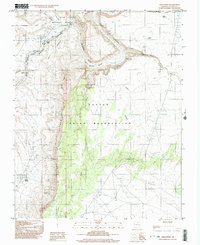
1999 Map of Lees Ferry
USGS Topo · Published 2003About this map
The confluence of the Colorado River and the Paria River at Lees Ferry defines this northern Arizona landscape, where the canyons of the Colorado begin their deep descent. This map shows the transition from the Glen Canyon reach into the upper walls of Marble Canyon, a historically significant crossing point for travelers and explorers. The rugged terrain is punctuated by significant vertical features such as the Echo Cliffs and Backbone, with the narrow Paria Canyon cutting through the northern section. Evidence of small-scale resource extraction appears in the form of several prospects scattered near the Echo Peaks Creek drainage. Further south, the map details the Navajo Indian Reservation boundary and reliable water sources like Navajo Spring and Navajo Spring No 2, which were critical for local settlement and travel in this arid environment.
Find a feature on this map
36 named features on this map. Tap any name to fly to it.
Don’t see what you’re looking for? This feature index may not catch every label — zoom into the map to look around manually.
Map Details
Editions of this 1999 Lees Ferry Map
This is the sole edition of this map. No revisions or reprints were ever made.
Other maps of this area

1886 · Echo Cliffs
USGS Topo · 1:250,000

1891 · Echo Cliffs
USGS Topo · 1:250,000

1951 · Lees Ferry NE
USGS Topo · 1:24,000

1954 · Lees Ferry NW
USGS Topo · 1:24,000

1954 · Lees Ferry SE
USGS Topo · 1:24,000

1954 · Lees Ferry SW
USGS Topo · 1:24,000

1954 · Tanner Wash
USGS Topo · 1:62,500

1954 · Leche-E Rock
USGS Topo · 1:62,500

1954 · Lees Ferry
USGS Topo · 1:62,500

1955 · Tanner Wash NE
USGS Topo · 1:24,000