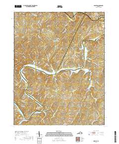
2019 Map of Leesville
USGS Topo · Published 2019About this map
Leesville Lake dominates the central landscape of this 2019 survey, where the borders of Bedford, Campbell, and Pittsylvania counties converge. The geography is defined by the winding course of the Roanoke River, also labeled as the Staunton River, which carves through the foothills of the Blue Ridge. Small communities and historical landing sites like Leesville, Browntown, and Brights are scattered along the ridges, connected by a network of winding county roads such as Chellis Ford Rd and Taylor Ford Rd.
Find a feature on this map
120 named features on this map. Tap any name to fly to it.
Don’t see what you’re looking for? This feature index may not catch every label — zoom into the map to look around manually.
Map Details
Editions of this 2019 Leesville Map
This is the sole edition of this map. No revisions or reprints were ever made.
Other maps of this area

1890 · Roanoke
USGS Topo · 1:125,000

1891 · Roanoke
USGS Topo · 1:125,000

1892 · Lynchburg
USGS Topo · 1:125,000

1921 · Chatham
USGS Topo · 1:48,000

1922 · Callands
USGS Topo · 1:48,000

1923 · Chatham
USGS Topo · 1:62,500

1924 · Callands
USGS Topo · 1:62,500

1944 · Callands
USGS Topo · 1:62,500

1947 · Roanoke
USGS Topo · 1:250,000

1951 · Moneta
USGS Topo · 1:62,500