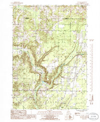
1985 Map of Leetsville
USGS Topo · Published 1986About this map
The Rapid River carves a deep valley through the glaciated terrain of Antrim and Kalkaska counties, defining the character of this Michigan landscape. As the river flows toward Rugg Pond, it passes through the Pere Marquette State Forest, a region marked by timber history and modern resource extraction. Industrial activity is evident in the numerous Gravel Pits and Oil Tanks scattered across the township lines of Helena and Custer. The small settlement of Leetsville sits at a critical transportation junction, where roads and a Pipeline intersect near a Cem and a Radio Tower. To the south, the village of Kalkaska anchors the map near Bird Lake and Log Lake, serving as a hub for the surrounding rural sections. This provisional survey captures the transition from dense forest to the infrastructure of energy and aggregate production in the mid-1980s.
Find a feature on this map
30 named features on this map. Tap any name to fly to it.
Don’t see what you’re looking for? This feature index may not catch every label — zoom into the map to look around manually.
Map Details
Editions of this 1985 Leetsville Map
This is the sole edition of this map. No revisions or reprints were ever made.
Other maps of this area

1954 · Traverse City
USGS Topo · 1:250,000

1956 · Mancelona
USGS Topo · 1:62,500

1956 · Kalkaska
USGS Topo · 1:62,500

1956 · Fife Lake
USGS Topo · 1:62,500

1957 · Elk Rapids
USGS Topo · 1:62,500

1958 · Traverse City
USGS Topo · 1:250,000

1975 · Mancelona NE
USGS Topo · 1:24,000

1975 · Mancelona NW
USGS Topo · 1:24,000

1983 · Traverse City
USGS Topo · 1:100,000
1983 · Alden
USGS Topo · 1:24,000