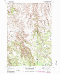
1969 Map of Lefevre Prairie
USGS Topo · Published 1984About this map
Lefevre Prairie and a series of high-altitude clearings including Scot Prairie and Camas Prairie dominate this upland landscape at the intersection of Gilliam, Wheeler, and Morrow counties. The terrain is deeply incised by a network of drainages such as Goff Canyon, Pullen Canyon, and Dutch Canyon, which feed into the area's many seasonal and perennial watercourses. Much of the southern portion is managed as part of the Umatilla National Forest, where the Dry Creek Trail provides access through the timbered draws.
Find a feature on this map
32 named features on this map. Tap any name to fly to it.
Don’t see what you’re looking for? This feature index may not catch every label — zoom into the map to look around manually.
Map Details
Editions of this 1969 Lefevre Prairie Map
2 editions found
Other maps of this area

1953 · Kimberly
USGS Topo · 1:62,500

1953 · Spray
USGS Topo · 1:62,500

1953 · Pendleton
USGS Topo · 1:250,000

1955 · Canyon City
USGS Topo · 1:250,000

1956 · Pendleton
USGS Topo · 1:250,000

1959 · Canyon City
USGS Topo · 1:250,000

1969 · Lefevre Prairie
USGS Topo · 1:24,000

1969 · Buttermilk Canyon
USGS Topo · 1:24,000
1969 · Lonerock
USGS Topo · 1:24,000

1969 · Chapin Creek
USGS Topo · 1:24,000