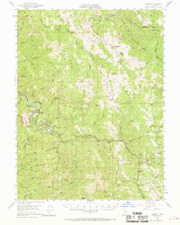
1952 Map of Leggett
USGS Topo · Published 1969About this map
The South Fork Eel River winds through the heart of this mid-century Mendocino County landscape, where the redwood timber economy and ranching roots intersect. The settlement of Leggett serves as a central hub, situated near the Leggett Airstrip and Edward R. Hickey State Park. The geography is defined by prominent ridges including Red Mountain, Brush Mountain, and Elkhorn Ridge, which separate the myriad creek drainages like Cedar Creek and Rattlesnake Creek. Evidence of early upland travel is found along Mail Ridge Road and several family holdings such as Bell Springs, Drewry Ranch, and Blue Rock Ranch. These scattered outposts and the presence of Redwine Cabin illustrate a pattern of isolated mountain living and seasonal resource extraction typical of the northern Coast Ranges before more modern infrastructure fully unified the region.
Find a feature on this map
54 named features on this map. Tap any name to fly to it.
Don’t see what you’re looking for? This feature index may not catch every label — zoom into the map to look around manually.
Map Details
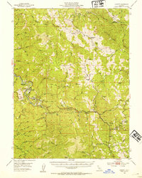
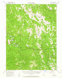
Editions of this 1952 Leggett Map
3 editions found
Other maps of this area

1920 · Cummings
USGS Topo · 1:62,500

1920 · Covelo
USGS Topo · 1:62,500

1920 · Harris
USGS Topo · 1:62,500

1921 · Westport
USGS Topo · 1:62,500

1921 · Briceland
USGS Topo · 1:62,500

1921 · Branscomb
USGS Topo · 1:62,500

1921 · Hoaglin
USGS Topo · 1:62,500

1922 · Island Mountain
USGS Topo · 1:62,500

1931 · Hoaglin
USGS Topo · 1:96,000

1935 · Hoaglin
USGS Topo · 1:125,000