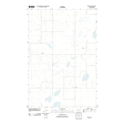
2011 Map of Lehr NW
USGS Topo · Published 2011About this map
Small rural burial grounds and a dense network of sectional roads define this landscape in the prairie pothole region of Logan County. The map reveals the deep roots of local family and congregational history through the presence of Saint Lucas Cemetery, Sukut Cemetery, and Emanuels Cemetery. These markers of early settlement are connected by a grid of corridors such as Bainstad Rd and Burnstad Rd, which navigate around hundreds of small, unnamed wetlands and depressions typical of the North Dakota plains. In the southern reach, Hope Cemetery sits near the junction of several county routes, providing a record of the community's geographical center in the early 21st century. The survey illustrates the persistence of the township-and-range system, where life and transit are dictated by the straight lines of the rural road network amidst a naturally irregular watery terrain.
Find a feature on this map
16 named features on this map. Tap any name to fly to it.
Don’t see what you’re looking for? This feature index may not catch every label — zoom into the map to look around manually.
Map Details
Editions of this 2011 Lehr NW Map
This is the sole edition of this map. No revisions or reprints were ever made.
Other maps of this area

1953 · Jamestown
USGS Topo · 1:250,000

1956 · Jamestown
USGS Topo · 1:250,000

1982 · Wishek NE
USGS Topo · 1:24,000

1982 · Lehr NW
USGS Topo · 1:24,000

1982 · Lehr NE
USGS Topo · 1:24,000

1982 · Lehr SW
USGS Topo · 1:24,000

1982 · Wishek
USGS Topo · 1:24,000
1982 · Lehr
USGS Topo · 1:24,000

1983 · Streeter SW
USGS Topo · 1:24,000

1983 · Streeter SE
USGS Topo · 1:24,000