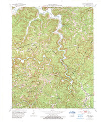
1952 Map of Leighton
USGS Topo · Published 1989About this map
Cumberland National Forest dominates this section of the Kentucky hills, where the boundaries of Estill, Jackson, Lee, and Owsley counties converge. The 1952 landscape is one of isolated hollows and ridge-top settlements, with small rural schools like Pond Sch and Salt Rock Sch serving local families. Industrial activity is concentrated in the northern ridges, marked by numerous oil wells and a namesake Silver Mine near Cavanaugh Creek. Transport follows the winding paths of Station Camp Creek and its many forks, connecting small communities such as Alumbaugh and Leighton. High points are guarded by fire observation posts, including the Drip Rock Lookout Tower and Old Orchard Lookout Tower, reflecting the era's focus on timber management and forest protection within the national forest system.
Find a feature on this map
70 named features on this map. Tap any name to fly to it.
Don’t see what you’re looking for? This feature index may not catch every label — zoom into the map to look around manually.
Map Details
Editions of this 1952 Leighton Map
4 editions found
Other maps of this area

1891 · Manchester
USGS Topo · 1:125,000

1892 · Richmond
USGS Topo · 1:125,000

1892 · Beattyville
USGS Topo · 1:125,000

1893 · London
USGS Topo · 1:125,000

1897 · Richmond
USGS Topo · 1:125,000

1897 · London
USGS Topo · 1:125,000

1952 · Alcorn
USGS Topo · 1:24,000

1952 · Leighton
USGS Topo · 1:24,000

1952 · Cobhill
USGS Topo · 1:24,000

1952 · Heidelberg
USGS Topo · 1:24,000