
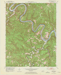
1952 Map of Heidelberg
USGS Topo · Published 1954About this map
The Kentucky River winds sharply through Lee and Estill counties in this 1952 survey, defining a landscape of deep valleys and narrow ridges such as Spencer Ridge and Hale Ridge. This river corridor was a vital industrial artery, evidenced by the presence of Lock No 13 and Lock No 14 and the tracks of the Louisville and Nashville railroad tracking the riverbanks through Heidelberg and Yellow Rock. The map documents a rural society built around local resource extraction, with numerous Oil Wells and Strip Mines appearing near Sturgeon Creek. Local history is captured in the network of one-room schools and small churches, such as Bear Track Mission Sch and St Theresa Ch, which served family enclaves reflected in name-labels like the Beatty Place Cem and Angel Cem.
Find a feature on this map
87 named features on this map. Tap any name to fly to it.
Don’t see what you’re looking for? This feature index may not catch every label — zoom into the map to look around manually.
Map Details
Editions of this 1952 Heidelberg Map
2 editions found
Other maps of this area

1891 · Manchester
USGS Topo · 1:125,000

1892 · Beattyville
USGS Topo · 1:125,000

1952 · Leighton
USGS Topo · 1:24,000

1952 · Beattyville
USGS Topo · 1:24,000

1952 · Cobhill
USGS Topo · 1:24,000

1952 · Irvine
USGS Topo · 1:24,000

1953 · Mc Kee
USGS Topo · 1:24,000

1953 · Booneville
USGS Topo · 1:24,000

1953 · Sturgeon
USGS Topo · 1:24,000

1953 · Zachariah
USGS Topo · 1:24,000