
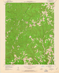
1953 Map of Zachariah
USGS Topo · Published 1956About this map
Cumberland National Forest dominates this mid-century landscape where the borders of Lee, Wolfe, Estill, and Powell Counties converge. The terrain is defined by a dense network of winding hollows and branches, including the curiously named Hell For Certain Creek. Small rural communities and family-named landmarks are scattered throughout these ridges, with Zachariah serving as a central point of reference. The presence of numerous schools and churches, such as Pine Hill Sch and Fincastle Ch, suggests a period of active local communal life before modern consolidation changed the rural Kentucky landscape. Toward the south, the North Fork Kentucky River cuts across the corner of the map, while Rogers and Torrent anchor the northern reaches. This 1953 survey captures the area at a time when remote homesteads and local institutions like Hopewell Sch still dotted the deep valleys of the Sandy Ridge.
Find a feature on this map
53 named features on this map. Tap any name to fly to it.
Don’t see what you’re looking for? This feature index may not catch every label — zoom into the map to look around manually.
Map Details
Editions of this 1953 Zachariah Map
2 editions found
Other maps of this area

1892 · Beattyville
USGS Topo · 1:125,000

1951 · Pomeroyton
USGS Topo · 1:24,000

1952 · Stanton
USGS Topo · 1:24,000

1952 · Slade
USGS Topo · 1:24,000

1952 · Tallega
USGS Topo · 1:24,000

1952 · Beattyville
USGS Topo · 1:24,000

1952 · Cobhill
USGS Topo · 1:24,000
1952 · Campton
USGS Topo · 1:24,000

1952 · Heidelberg
USGS Topo · 1:24,000

1957 · Jenkins
USGS Topo · 1:250,000