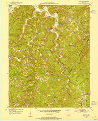
1952 Map of Leighton
USGS Topo · Published 1955About this map
Cumberland National Forest dominates this landscape, where the ridges of Hurd Ridge and Happy Top Mtn meet the deep drainages of Station Camp Creek. This 1952 study documents a rugged Appalachian topography where small communities and family farms are tethered to the creek bottoms and narrow ridge tops. Settlements like Drip Rock, Alumbaugh, and Leighton serve as local anchors, while high points are utilized for fire detection at the Drip Rock Lookout Tower and Old Orchard Lookout Tower.
Find a feature on this map
104 named features on this map. Tap any name to fly to it.
Don’t see what you’re looking for? This feature index may not catch every label — zoom into the map to look around manually.
Map Details
Editions of this 1952 Leighton Map
4 editions found
Other maps of this area

1891 · Manchester
USGS Topo · 1:125,000

1892 · Richmond
USGS Topo · 1:125,000

1892 · Beattyville
USGS Topo · 1:125,000

1893 · London
USGS Topo · 1:125,000

1897 · Richmond
USGS Topo · 1:125,000

1897 · London
USGS Topo · 1:125,000

1952 · Alcorn
USGS Topo · 1:24,000

1952 · Leighton
USGS Topo · 1:24,000

1952 · Cobhill
USGS Topo · 1:24,000

1952 · Heidelberg
USGS Topo · 1:24,000