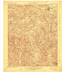
1925 Map of Leitchfield
USGS Topo · Published 1925About this map
The Leitchfield area of central Kentucky is defined by a dense network of early 20th-century rural infrastructure, where the Illinois Central railroad cuts through the north, connecting Millwood and Caneyville. This 1920s-era landscape reveals an agrarian society organized around dozens of local institutions, including the Myrtle Grove and Quisenberry schools. Small-scale resource extraction is evident at the Meredith Coal Bank near the Grayson and Edmonson county line.
Find a feature on this map
93 named features on this map. Tap any name to fly to it.
Don’t see what you’re looking for? This feature index may not catch every label — zoom into the map to look around manually.
Map Details
Editions of this 1925 Leitchfield Map
2 editions found
Other maps of this area

1914 · Little Muddy
USGS Topo · 1:62,500

1922 · Leitchfield
USGS Topo · 1:48,000

1922 · Brownsville
USGS Topo · 1:62,500

1922 · Mammoth Cave
USGS Topo · 1:62,500

1923 · Mammoth Cave
USGS Topo · 1:62,500

1923 · Brownsville
USGS Topo · 1:62,500

1925 · Spring Lick
USGS Topo · 1:62,500

1925 · Cub Run
USGS Topo · 1:62,500

1925 · Leitchfield
USGS Topo · 1:62,500

1932 · Big Clifty
USGS Topo · 1:62,500