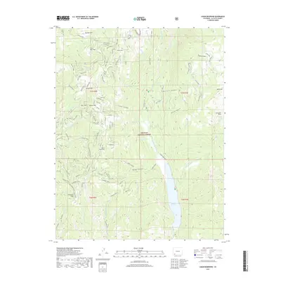
2019 Map of Lemon Reservoir
USGS Topo · Published 2019About this map
Lemon Reservoir dominates the lower elevations of this high-country survey, where the Florida River is captured by the dam before flowing south. Located within the San Juan National Forest, the landscape is defined by the steep relief of Missionary Ridge and the winding drainages of Shearer Creek and Youngs Canyon. The mapping reveals a network of high-altitude parks and passes, such as Silver Pass, Kroeger Park, and Horse Thief Park, which suggest historical transit routes and grazing lands used before the modern era. The presence of remote water bodies like Lost Lake and the Stump Lakes high on the eastern benches illustrates the complex hydrology of this alpine environment. Only one primary road, Florida (CR 243), provides access into this terrain, emphasizing the protected and largely undeveloped nature of the forest interior.
Find a feature on this map
49 named features on this map. Tap any name to fly to it.
Don’t see what you’re looking for? This feature index may not catch every label — zoom into the map to look around manually.
Map Details
Editions of this 2019 Lemon Reservoir Map
This is the sole edition of this map. No revisions or reprints were ever made.
Other maps of this area

1898 · Durango
USGS Topo · 1:62,500

1898 · Engineer Mountain
USGS Topo · 1:62,500

1900 · Engineer Mountain
USGS Topo · 1:62,500

1900 · Needle Mountains
USGS Topo · 1:62,500

1902 · Needle Mountains
USGS Topo · 1:62,500

1907 · Durango
USGS Topo · 1:62,500

1908 · Engineer Mountain
USGS Topo · 1:62,500

1908 · Ignacio
USGS Topo · 1:125,000

1908 · Durango
USGS Topo · 1:62,500

1924 · Ignacio
USGS Topo · 1:125,000