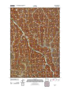
2011 Map of Lena
USGS Topo · Published 2011About this map
Little Butter Creek winds through the high desert landscape of Morrow County, defining the drainage patterns and historical transportation routes in this part of eastern Oregon. Near the center of the sheet, the Pleasant Point Cemetery sits along Little Butter Creek Rd, serving as a silent record of early families in the region. The topography is shaped by significant elevation changes, from the prominent Morris Butte in the northwest to the high southern ridge of Jones Hill Summit. Small settlements and landmarks like Lena and the Vey Ranch are concentrated in the lower canyon areas, such as Luckman Canyon and Jones Canyon, where water and workable land were more accessible. This 2011 survey documents a sparsely populated ranching landscape where local geography remains the primary driver of development.
Find a feature on this map
11 named features on this map. Tap any name to fly to it.
Don’t see what you’re looking for? This feature index may not catch every label — zoom into the map to look around manually.
Map Details
Editions of this 2011 Lena Map
This is the sole edition of this map. No revisions or reprints were ever made.
Other maps of this area

1908 · Umatilla
USGS Topo · 1:125,000

1953 · Pendleton
USGS Topo · 1:250,000

1956 · Pendleton
USGS Topo · 1:250,000

1967 · Freezeout Ridge
USGS Topo · 1:24,000

1968 · Hoodlum Canyon
USGS Topo · 1:24,000

1968 · Lena
USGS Topo · 1:24,000

1968 · Gleason Butte
USGS Topo · 1:24,000

1968 · Vey Ranch
USGS Topo · 1:24,000

1968 · Butter Creek Junction
USGS Topo · 1:24,000
1968 · Echo SW
USGS Topo · 1:24,000