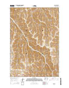
2014 Map of Lena
USGS Topo · Published 2014About this map
Lena sits at the junction of Or-74 and Hughes Hill Rd in this 2014 survey of Morrow County. This section of Oregon's interior is defined by a complex network of drainage canyons and high points, including Morris Butte and Jones Hill Summit. The landscape is heavily dissected by seasonal watercourses such as Little Butter Cr, which winds through the central terrain between Ayers Canyon and Luckman Canyon. Genealogists will find the Pleasant Point Cem situated near the head of Newman Canyon, while local history enthusiasts can trace the early road alignments of Healy Rd as it traverses the western ridges above Johnson Canyon and Milk Canyon. The map provides a precise view of the topography surrounding these named geographical features, showcasing the transition from deep canyon floors like Buttermilk Canyon to the prominent heights of Jones Hill.
Find a feature on this map
22 named features on this map. Tap any name to fly to it.
Don’t see what you’re looking for? This feature index may not catch every label — zoom into the map to look around manually.
Map Details
Editions of this 2014 Lena Map
This is the sole edition of this map. No revisions or reprints were ever made.
Other maps of this area

1908 · Umatilla
USGS Topo · 1:125,000

1953 · Pendleton
USGS Topo · 1:250,000

1956 · Pendleton
USGS Topo · 1:250,000

1967 · Freezeout Ridge
USGS Topo · 1:24,000

1968 · Hoodlum Canyon
USGS Topo · 1:24,000

1968 · Lena
USGS Topo · 1:24,000

1968 · Gleason Butte
USGS Topo · 1:24,000

1968 · Vey Ranch
USGS Topo · 1:24,000

1968 · Butter Creek Junction
USGS Topo · 1:24,000
1968 · Echo SW
USGS Topo · 1:24,000