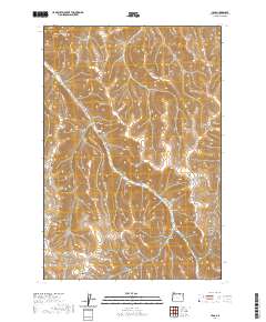
2020 Map of Lena
USGS Topo · Published 2020About this map
Lena and its surrounding canyons define this corner of Morrow County, where the high-desert plateau is deeply etched by the winding course of Little Butter Cr. This landscape is marked by the distinct topographic signatures of Morris Canyon, Newman Canyon, and Milk Canyon, illustrating the erosive power of seasonal drainages. For local history and genealogy researchers, the Pleasant Point Cem stands as a significant landmark of the area's rural settlement patterns, situated north of the community of Lena.
Find a feature on this map
21 named features on this map. Tap any name to fly to it.
Don’t see what you’re looking for? This feature index may not catch every label — zoom into the map to look around manually.
Map Details
Editions of this 2020 Lena Map
This is the sole edition of this map. No revisions or reprints were ever made.
Other maps of this area

1908 · Umatilla
USGS Topo · 1:125,000

1953 · Pendleton
USGS Topo · 1:250,000

1956 · Pendleton
USGS Topo · 1:250,000

1967 · Freezeout Ridge
USGS Topo · 1:24,000

1968 · Hoodlum Canyon
USGS Topo · 1:24,000

1968 · Lena
USGS Topo · 1:24,000

1968 · Gleason Butte
USGS Topo · 1:24,000

1968 · Vey Ranch
USGS Topo · 1:24,000

1968 · Butter Creek Junction
USGS Topo · 1:24,000
1968 · Echo SW
USGS Topo · 1:24,000