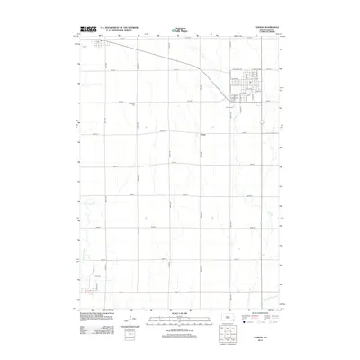
2012 Map of Lennox
USGS Topo · Published 2012About this map
Naomi and the surrounding agricultural landscape of Lincoln County define this survey, which documents the region's orderly section-line road network. The map detail is anchored by the grid of South Dakota's eastern prairies, where the Vermillion River and Long Cr wind through the township. Significant local history markers include the Lennox Cem, Chancellor Cem, and Davis Cem, which serve as permanent records of the early families who settled this territory. Within the street plan, landmarks such as Park Dr and various municipal roads illustrate the 21st-century footprint of the community. To the southeast, the managed hydrology of the landscape is represented by Ditch Number Eight, reflecting the area's long-term commitment to water management and land cultivation.
Find a feature on this map
41 named features on this map. Tap any name to fly to it.
Don’t see what you’re looking for? This feature index may not catch every label — zoom into the map to look around manually.
Map Details
Editions of this 2012 Lennox Map
This is the sole edition of this map. No revisions or reprints were ever made.
Other maps of this area

1897 · Canton
USGS Topo · 1:125,000

1898 · Parker
USGS Topo · 1:125,000

1900 · Canton
USGS Topo · 1:125,000

1955 · Sioux Falls
USGS Topo · 1:250,000

1958 · Sioux Falls
USGS Topo · 1:250,000

1962 · Tea
USGS Topo · 1:24,000

1962 · Lennox NW
USGS Topo · 1:24,000

1964 · Worthing
USGS Topo · 1:24,000

1964 · Lennox
USGS Topo · 1:24,000
1968 · Beresford NW
USGS Topo · 1:24,000