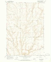
1965 Map of Lenzie Ranch
USGS Topo · Published 1966About this map
Lenzie Ranch serves as a primary landmark in this mid-1960s landscape along the Washington-Benton Co. border. The terrain is defined by the drainage of East Branch Glade Creek and a network of rural roads that likely denote early family landholdings and farm access. A local Fire Sta is situated near the ranch, indicating a localized hub of activity within the surrounding agricultural or grazing land.
Find a feature on this map
14 named features on this map. Tap any name to fly to it.
Don’t see what you’re looking for? This feature index may not catch every label — zoom into the map to look around manually.
Map Details
Editions of this 1965 Lenzie Ranch Map
This is the sole edition of this map. No revisions or reprints were ever made.
Other maps of this area

1906 · Blalock Island
USGS Topo · 1:125,000

1908 · Blalock Island
USGS Topo · 1:125,000

1915 · Prosser
USGS Topo · 1:125,000

1917 · Prosser
USGS Topo · 1:125,000

1953 · Pendleton
USGS Topo · 1:250,000

1953 · Walla Walla
USGS Topo · 1:250,000

1956 · Pendleton
USGS Topo · 1:250,000

1958 · Walla Walla
USGS Topo · 1:250,000

1962 · Canoe Ridge
USGS Topo · 1:24,000

1962 · Blalock Island
USGS Topo · 1:24,000