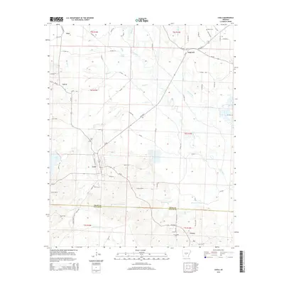
2014 Map of Leola
USGS Topo · Published 2014About this map
The town of Leola serves as the primary hub of this 2014 survey, situated where Ar 229 S intersects with local routes near the Grant and Dallas County line. The landscape is defined by the winding course of the Saline River and an intricate network of wetlands, including Beaverdam Slough and Moores Slough, which dominate the eastern and southern reaches. Small settlements like Dogwood and Thiel appear along the northern roads, while the southern section transitions toward the communities of Cooney and Ivy. For those researching local family history, the map identifies several burial grounds such as Taylor Cem near the town center and Crowder Cem further south. The drainage patterns of Guesses Cr and Brush Cr illustrate the low-lying, water-rich environment of the region, providing a detailed look at the rural geography before modern development shifted the local character.
Find a feature on this map
81 named features on this map. Tap any name to fly to it.
Don’t see what you’re looking for? This feature index may not catch every label — zoom into the map to look around manually.
Map Details
Editions of this 2014 Leola Map
This is the sole edition of this map. No revisions or reprints were ever made.
Other maps of this area

1955 · Little Rock
USGS Topo · 1:250,000

1956 · Little Rock
USGS Topo · 1:250,000

1960 · Little Rock
USGS Topo · 1:250,000

1963 · Prattsville
USGS Topo · 1:24,000

1964 · Poyen
USGS Topo · 1:24,000

1964 · Little Rock
USGS Topo · 1:250,000

1964 · Sheridan
USGS Topo · 1:24,000

1964 · Bunn
USGS Topo · 1:24,000
1964 · Millerville
USGS Topo · 1:24,000
1965 · Leola
USGS Topo · 1:24,000