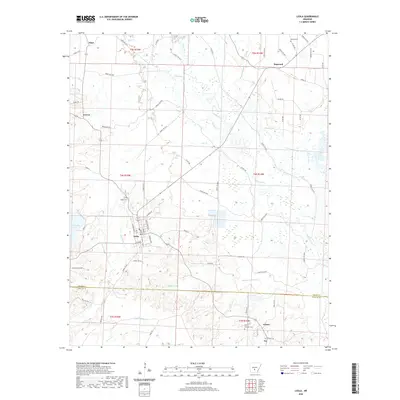
2020 Map of Leola
USGS Topo · Published 2020About this map
Leola serves as the central hub of this South Arkansas landscape, where the Saline River and its intricate drainage network define the geography. The terrain is characterized by winding waterways and sloughs, including Beaverdam Slough and Moores Slough, alongside significant water bodies like Tolar Lake and Cox Creek Lake. This map captures a rural environment integrated with the timberlands of the region, evidenced by the extensive network of Forest Roads such as Forest Rd 9400 and Forest Rd 9012. For those researching local roots, the map identifies family-named burial grounds like Taylor Cem, Moores Cem, and Crowder Cem. Smaller named locales such as Thiel, Dogwood, and Cooney appear along the county roads and forest tracks, showing the persistent settlement pattern across the Grant and Dallas County line.
Find a feature on this map
79 named features on this map. Tap any name to fly to it.
Don’t see what you’re looking for? This feature index may not catch every label — zoom into the map to look around manually.
Map Details
Editions of this 2020 Leola Map
This is the sole edition of this map. No revisions or reprints were ever made.
Other maps of this area

1955 · Little Rock
USGS Topo · 1:250,000

1956 · Little Rock
USGS Topo · 1:250,000

1960 · Little Rock
USGS Topo · 1:250,000

1963 · Prattsville
USGS Topo · 1:24,000

1964 · Poyen
USGS Topo · 1:24,000

1964 · Little Rock
USGS Topo · 1:250,000

1964 · Sheridan
USGS Topo · 1:24,000

1964 · Bunn
USGS Topo · 1:24,000
1964 · Millerville
USGS Topo · 1:24,000
1965 · Leola
USGS Topo · 1:24,000