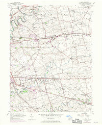
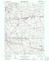
1956 Map of Leola
USGS Topo · Published 1970About this map
Leola and Bareville sit at the heart of this agricultural landscape in Lancaster County, where the settlement pattern follows the productive limestone soils and the established path of the Lincoln Highway. The map captures a transition period in the mid-20th century, showing the established Penn Central rail lines alongside emerging modern landmarks like the Drive-in Theater and an Amusement Park near Greenland. Traditional community hubs remain central to the geography, from the Groffdale Ch and Carpenter Ch to numerous one-room schoolhouse sites such as Sunnyside Sch and Maple Grove Sch. The intricate drainage of Conestoga Creek and Pequea Creek carves through the townships of Upper Leacock and East Lampeter, illustrating the relationship between the rolling terrain and the region's historic farmsteads and crossroads villages.
Find a feature on this map
79 named features on this map. Tap any name to fly to it.
Don’t see what you’re looking for? This feature index may not catch every label — zoom into the map to look around manually.
Map Details
Editions of this 1956 Leola Map
5 editions found
Other maps of this area

1902 · Lancaster
USGS Topo · 1:62,500

1904 · Lancaster
USGS Topo · 1:62,500

1906 · New Holland
USGS Topo · 1:62,500

1908 · New Holland
USGS Topo · 1:62,500

1912 · Quarryville
USGS Topo · 1:62,500

1912 · Mc Calls Ferry
USGS Topo · 1:62,500

1941 · New Holland
USGS Topo · 1:62,500

1943 · Lancaster
USGS Topo · 1:62,500

1943 · Quarryville
USGS Topo · 1:62,500

1943 · Mc Calls Ferry
USGS Topo · 1:62,500
Featured Places
- West Lampeter Township, PA
- Leacock, Upper Leacock Township
- Paradise Township, PA
- Brownstown, West Earl Township
- Manheim Township, PA