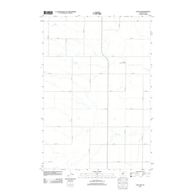
2012 Map of Leola SW
USGS Topo · Published 2012About this map
Plainview Colony Number Two sits as the central landmark of this landscape in Edmunds County, reflecting the continued presence of Hutterite agricultural settlements in South Dakota. The area is defined by a strictly orthogonal road network of gravel and local routes, including 360th Ave and 122nd St, which overlay a prairie terrain carved by seasonal stream channels. These watercourses meander across the township lines, contrasting with the rigid section boundaries. This 2012 survey by the U.S. Geological Survey shows a sparsely populated region where large-scale farming and communal living structures dominate the land use, maintaining a spatial organization that has persisted through generations of rural development.
Find a feature on this map
15 named features on this map. Tap any name to fly to it.
Don’t see what you’re looking for? This feature index may not catch every label — zoom into the map to look around manually.
Map Details
Editions of this 2012 Leola SW Map
This is the sole edition of this map. No revisions or reprints were ever made.
Other maps of this area

1899 · Ellendale
USGS Topo · 1:125,000

1899 · Northville
USGS Topo · 1:125,000

1954 · Aberdeen
USGS Topo · 1:250,000

1956 · Aberdeen
USGS Topo · 1:250,000

1970 · Wetonka South
USGS Topo · 1:24,000

1970 · Mina NW
USGS Topo · 1:24,000

1970 · Leola
USGS Topo · 1:24,000
1970 · Mina
USGS Topo · 1:24,000
1970 · Wetonka North
USGS Topo · 1:24,000

1970 · Leola SW
USGS Topo · 1:24,000