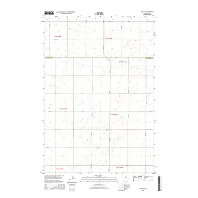
2015 Map of Leola SW
USGS Topo · Published 2015About this map
The communal agricultural landscape of Deerfield Colony defines the eastern portion of this South Dakota survey, situated along the border of McPherson and Edmunds Counties. The map illustrates a strictly organized section-line grid system, typical of the Great Plains, where gravel and soil roads like 363rd Ave and 124th St segment the rolling prairie into precise square-mile townships. This 2015 edition documents the intricate drainage patterns of the northern plains, where numerous small, unnamed basins and seasonal wetlands punctuate the topography between Cr-18 and the southern reaches of t124n r67w. The spatial arrangement of the Deerfield Colony buildings against this repetitive section grid provides a clear look at how human settlement and large-scale farming have adapted to the water-scarce environment of the north-central part of the state.
Find a feature on this map
24 named features on this map. Tap any name to fly to it.
Don’t see what you’re looking for? This feature index may not catch every label — zoom into the map to look around manually.
Map Details
Editions of this 2015 Leola SW Map
This is the sole edition of this map. No revisions or reprints were ever made.
Other maps of this area

1899 · Ellendale
USGS Topo · 1:125,000

1899 · Northville
USGS Topo · 1:125,000

1954 · Aberdeen
USGS Topo · 1:250,000

1956 · Aberdeen
USGS Topo · 1:250,000

1970 · Wetonka South
USGS Topo · 1:24,000

1970 · Mina NW
USGS Topo · 1:24,000

1970 · Leola
USGS Topo · 1:24,000
1970 · Mina
USGS Topo · 1:24,000
1970 · Wetonka North
USGS Topo · 1:24,000

1970 · Leola SW
USGS Topo · 1:24,000