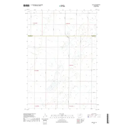
2017 Map of Leola SW
USGS Topo · Published 2017About this map
Mcpherson Co Edmunds Co defines the central axis of this landscape, marking the transition between the rolling prairie townships of northern South Dakota. The 2017 terrain is characterized by a dense network of seasonal wetlands and small basins typical of the glaciated plains, woven between a strict sectional grid of rural roads. Important local transit corridors including Co Hwy 18 and Co Rd 16 provide the primary infrastructure for the region's agricultural operations. The map illustrates the persistent 19th-century land survey system, with townships like t124n r67w and t124n r68w clearly delineated. This documentation of contemporary land use and hydrography captures the intricate drainage patterns that influence modern farming and ranching boundaries across the county line.
Find a feature on this map
25 named features on this map. Tap any name to fly to it.
Don’t see what you’re looking for? This feature index may not catch every label — zoom into the map to look around manually.
Map Details
Editions of this 2017 Leola SW Map
This is the sole edition of this map. No revisions or reprints were ever made.
Other maps of this area

1899 · Ellendale
USGS Topo · 1:125,000

1899 · Northville
USGS Topo · 1:125,000

1954 · Aberdeen
USGS Topo · 1:250,000

1956 · Aberdeen
USGS Topo · 1:250,000

1970 · Wetonka South
USGS Topo · 1:24,000

1970 · Mina NW
USGS Topo · 1:24,000

1970 · Leola
USGS Topo · 1:24,000
1970 · Mina
USGS Topo · 1:24,000
1970 · Wetonka North
USGS Topo · 1:24,000

1970 · Leola SW
USGS Topo · 1:24,000