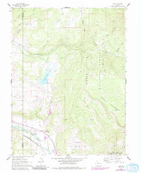
1961 Map of Leon
USGS Topo · Published 1988About this map
The Denver and Rio Grande Western railroad corridor follows the path of the Roaring Fork River, serving as the primary infrastructure artery for this mountain valley. The settlement of El Jebel sits at a critical junction where irrigation and livestock management take priority, evidenced by the Home Supply Ditch and numerous water features like the Spring Pork Reservoir. The landscape is defined by the transition from ranching lands along Cattle Creek to the high elevations of Basalt Mountain.
Find a feature on this map
28 named features on this map. Tap any name to fly to it.
Don’t see what you’re looking for? This feature index may not catch every label — zoom into the map to look around manually.
Map Details
Editions of this 1961 Leon Map
4 editions found
Other maps of this area

1909 · Mount Jackson
USGS Topo · 1:125,000

1911 · Mount Jackson
USGS Topo · 1:125,000

1927 · Glenwood Springs
USGS Topo · 1:125,000

1930 · Glenwood Springs
USGS Topo · 1:125,000

1957 · Leadville
USGS Topo · 1:250,000

1959 · Leadville
USGS Topo · 1:250,000

1960 · Leadville
USGS Topo · 1:250,000

1961 · Mount Sopris
USGS Topo · 1:24,000

1961 · Carbondale
USGS Topo · 1:24,000

1961 · Leon
USGS Topo · 1:24,000