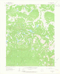
1960 Map of Leon Peak
USGS Topo · Published 1963About this map
Leon Peak rises as the central landmark of this high-elevation landscape within the Grand Mesa National Forest. The 1960 field check reveals an intricate network of water management, where numerous small bodies of water like Leon Lake, Colby Horse Park Reservoir, and Island Res are linked by topographic features and infrastructure. The presence of the Leon Tunnel and several aqueducts underscores the systematic effort to capture and direct snowmelt across the plateau for downstream use in Delta and Mesa counties.
Find a feature on this map
72 named features on this map. Tap any name to fly to it.
Don’t see what you’re looking for? This feature index may not catch every label — zoom into the map to look around manually.
Map Details
Editions of this 1960 Leon Peak Map
5 editions found

Other maps of this area

1955 · Collbran
USGS Topo · 1:24,000

1955 · Grand Mesa
USGS Topo · 1:24,000

1955 · The Meadows
USGS Topo · 1:24,000

1956 · Montrose
USGS Topo · 1:250,000

1957 · Leadville
USGS Topo · 1:250,000

1959 · Leadville
USGS Topo · 1:250,000

1959 · Montrose
USGS Topo · 1:250,000

1960 · Leadville
USGS Topo · 1:250,000

1960 · Montrose
USGS Topo · 1:250,000

1960 · Leon Peak
USGS Topo · 1:24,000