
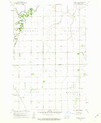
1959 Map of Leonard
USGS Topo · Published 1960About this map
The Northern Pacific railroad cuts a diagonal path through this Red River Valley landscape, serving as the industrial spine for the settlement of Leonard. This 1959 planetable survey captures a transition in the eastern North Dakota prairie, where the meandering course of the Maple River in the north contrasts with the rigid grid of townships like Addison and Leonard. Evidence of local industry and community life is visible in features such as the Claypit and rural congregations at Bethel Ch and West Prairie Ch. The topography, mapped with five-foot contour intervals, reveals subtle variations in the land, including a natural Spring located near the railroad tracks. This document records the spatial organization of Cass and Richland counties before later twentieth-century agricultural shifts further consolidated these rural townships.
Find a feature on this map
14 named features on this map. Tap any name to fly to it.
Don’t see what you’re looking for? This feature index may not catch every label — zoom into the map to look around manually.
Map Details
Editions of this 1959 Leonard Map
This is the sole edition of this map. No revisions or reprints were ever made.
Other maps of this area

1895 · Casselton
USGS Topo · 1:125,000

1897 · Casselton
USGS Topo · 1:125,000

1953 · Fargo
USGS Topo · 1:250,000

1956 · Fargo
USGS Topo · 1:250,000

1959 · Kindred
USGS Topo · 1:24,000

1960 · Power
USGS Topo · 1:24,000

1960 · Barrie
USGS Topo · 1:24,000

1960 · Coburn
USGS Topo · 1:24,000

1961 · Durbin
USGS Topo · 1:24,000
1961 · Casselton SE
USGS Topo · 1:24,000