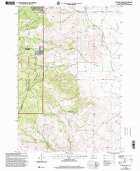
1997 Map of Leonard Creek
USGS Topo · Published 2001About this map
The high elevations of the Tobacco Root Mountains define this section of the Beaverhead National Forest in Madison County. During the late 1990s, the landscape remained characterized by its network of high-country drainages and evidence of mineral exploration. A cluster of mining activity is visible in the northwest corner, including a Mine Shaft, Prospect, and Mine located near Aurora Creek. The map shows a complex watershed where Leonard Creek and Dry Leonard Creek descend from the ridges toward the east, eventually feeding into the larger North Meadow Creek system. These steep drainages, including Slim Sam Creek and Fletcher Creek, illustrate the difficult terrain that historically challenged both prospectors and forest managers. The presence of these named shafts and prospects alongside remote waters like Virginia Creek provides a clear record of the area's dual identity as both a resource frontier and a protected wilderness.
Find a feature on this map
18 named features on this map. Tap any name to fly to it.
Don’t see what you’re looking for? This feature index may not catch every label — zoom into the map to look around manually.
Map Details
Editions of this 1997 Leonard Creek Map
This is the sole edition of this map. No revisions or reprints were ever made.
Other maps of this area

1888 · Three Forks
USGS Topo · 1:250,000

1894 · Three Forks
USGS Topo · 1:250,000

1895 · Three Forks
USGS Topo · 1:250,000

1947 · Bozeman
USGS Topo · 1:250,000

1948 · Bozeman
USGS Topo · 1:250,000

1949 · Ennis
USGS Topo · 1:62,500

1949 · Norris
USGS Topo · 1:62,500

1950 · Harrison
USGS Topo · 1:62,500

1950 · Virginia City
USGS Topo · 1:62,500

1951 · Norris
USGS Topo · 1:62,500