1950 Map of Leonardtown
USGS Topo · Published 1964About this map
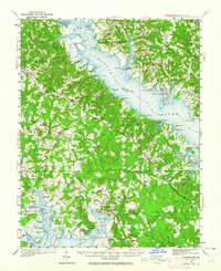
The Patuxent River dominates this mid-century portrait of Southern Maryland, carving a wide path through the tobacco-growing heart of St. Mary's and Calvert Counties. The landscape is defined by its deep relationship with the water, as evidenced by the numerous landings and wharves such as Williams Wharf, St Cuthbert Wharf, and Abells Wharf that served as vital nodes for local commerce. Settlement patterns are concentrated in inland crossroads like Mechanicsville and the county seat at Leonardtown, while coastal communities like Broomes Island and Kenwood Beach suggest the region's evolving character as a residential and recreation destination.
Find a feature on this map
115 named features on this map. Tap any name to fly to it.
Don’t see what you’re looking for? This feature index may not catch every label — zoom into the map to look around manually.
Map Details
Editions of this 1950 Leonardtown Map
This is the sole edition of this map. No revisions or reprints were ever made.
Other maps of this area

1892 · Leonardtown
USGS Topo · 1:62,500

1892 · Drum Point
USGS Topo · 1:62,500

1892 · Prince Frederick
USGS Topo · 1:62,500

1892 · Brandywine
USGS Topo · 1:62,500

1892 · Piney Point
USGS Topo · 1:62,500

1892 · Montross
USGS Topo · 1:62,500

1893 · Sharps Island
USGS Topo · 1:62,500

1894 · Wicomico
USGS Topo · 1:62,500

1894 · Piney Point
USGS Topo · 1:62,500

1894 · Point Lookout
USGS Topo · 1:62,500
Featured Places
- Lexington Park, MD
- California, Lexington Park
- Wildewood, Lexington Park
- Golden Beach, MD
- Leonardtown, MD