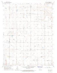
1966 Map of Leoti 3 SW
USGS Topo · Published 1967About this map
West Hibbard and Hartland townships define this Western Kansas landscape, which is characterized by a sparse, industrial grid during the mid-1960s. The terrain is marked primarily by the infrastructure of the energy industry, with numerous sites labeled as Gas Well, Oil Well, and Oil Wells scattered across the high plains. A prominent Pipeline cuts diagonally across the southern half of the map, illustrating the critical role of transport in this remote resource-extraction economy. Unlike more populated regions, this survey shows a landscape of wide-open spaces where section lines and unimproved roads facilitate the maintenance of energy fields rather than dense settlement. The map serves as a detailed record of the subterranean value found beneath the surface of Kearny County, showing the exact distribution of wells during a peak period of regional energy production.
Find a feature on this map
6 named features on this map. Tap any name to fly to it.
Don’t see what you’re looking for? This feature index may not catch every label — zoom into the map to look around manually.
Map Details
Editions of this 1966 Leoti 3 SW Map
2 editions found
Other maps of this area

1891 · Larned
USGS Topo · 1:125,000

1900 · Syracuse
USGS Topo · 1:125,000

1900 · Lakin
USGS Topo · 1:125,000

1920 · Syracuse
USGS Topo · 1:125,000

1955 · Dodge City
USGS Topo · 1:250,000

1955 · Scott City
USGS Topo · 1:250,000

1958 · Dodge City
USGS Topo · 1:250,000

1958 · Scott City
USGS Topo · 1:250,000

1959 · Dodge City
USGS Topo · 1:250,000

1965 · Leoti 3 NW
USGS Topo · 1:24,000