
1970 Map of Leoti NW
USGS Topo · Published 1972About this map
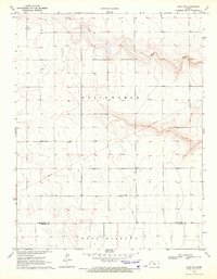
White Woman Creek carves a winding path across this portion of Wichita County, defining the terrain with sharp contour changes against the surrounding high plains. The landscape in 1970 reflects a strictly rural and industrial utility, characterized by extensive agricultural wells and the heavy transport corridor of the Missouri Pacific railroad running along the northern edge. Evidence of local infrastructure and resource extraction is visible through the Gaging Station located near the creek and a Gravel Pit positioned to the north. Smaller drainage features like Sand Cr feed into the primary waterway, illustrating the natural drainage patterns that have historically shaped the settlement and land use of the Leoti and White Woman townships.
Find a feature on this map
8 named features on this map. Tap any name to fly to it.
Don’t see what you’re looking for? This feature index may not catch every label — zoom into the map to look around manually.
Map Details
Editions of this 1970 Leoti NW Map
This is the sole edition of this map. No revisions or reprints were ever made.
Other maps of this area

1955 · Scott City
USGS Topo · 1:250,000

1958 · Scott City
USGS Topo · 1:250,000

1968 · Russell Springs 3 SW
USGS Topo · 1:24,000

1968 · Russell Springs 3 SE
USGS Topo · 1:24,000

1970 · Sharon Springs 4 SE
USGS Topo · 1:24,000

1970 · Selkirk SE
USGS Topo · 1:24,000

1970 · Selkirk
USGS Topo · 1:24,000

1970 · Leoti
USGS Topo · 1:24,000

1970 · Lydia
USGS Topo · 1:24,000
1970 · Leoti SW
USGS Topo · 1:24,000