
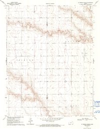
1970 Map of Sharon Springs 4 SE
USGS Topo · Published 1971About this map
The high plains of Western Kansas intersect at the Greeley Co Wichita Co line in this 1970 survey, revealing a landscape defined by expansive township boundaries and isolated landmarks. The northern reaches are marked by the winding path of Ladder Creek, which cuts through the plateau near Beaver. This area is characteristic of the region’s agricultural development, with a network of section lines and water wells supporting the townships of Tribune and Leoti. Cultural centers are sparse but significant, including the St Theresa Ch and a local Cem, which serve as primary reference points for family historians and researchers tracing the mid-century footprint of these rural communities.
Find a feature on this map
7 named features on this map. Tap any name to fly to it.
Don’t see what you’re looking for? This feature index may not catch every label — zoom into the map to look around manually.
Map Details
Editions of this 1970 Sharon Springs 4 SE Map
2 editions found
Other maps of this area

1955 · Scott City
USGS Topo · 1:250,000

1958 · Scott City
USGS Topo · 1:250,000

1968 · Russell Springs 3 SW
USGS Topo · 1:24,000

1968 · Russell Springs 3 NW
USGS Topo · 1:24,000

1968 · Sharon Springs 4 NW
USGS Topo · 1:24,000

1968 · Sharon Springs 4 NE
USGS Topo · 1:24,000

1970 · Sharon Springs 4 SW
USGS Topo · 1:24,000

1970 · Selkirk
USGS Topo · 1:24,000

1970 · Leoti NW
USGS Topo · 1:24,000

1970 · Selkirk NW
USGS Topo · 1:24,000